With the heat of summer upon us, it can be hard to keep cool if you don’t have a swimming pool. Luckily, there are plenty of swimming spots throughout the 209 that help keep the warmer weather in check. While they may be located just a bit off the beaten path, these secret pools give visitors the chance to get their toes wet — or dive on in — surrounded by the beauty and splendor that only our area code can offer.
Arnold Rim Trail
With over 17 miles of trail, hikers can encounter numerous swimming holes on this path. Originally designed for hikers, bikers and equestrians, those in search of a safe spot to swim also frequent the trail, which loops around the San Antonio Creek. Thanks to this, it’s easy to take a break and go for a dip in one of the creek’s many pools. The Arnold Rim Trail connects the many wonders of public lands along the Ebbetts Pass National Scenic Byway stretch of Hwy 4 to its communities, creating a high level of access for its residents and visitors. Dogs are allowed on the trail, but be wary of black bear sightings.
The Arnold Rim Trail begins at the Sierra Nevada Logging Museum in the community of White Pines. From eastbound Highway 4 in Arnold, veer left onto Blagen Road just past the Chevron gas station. Follow Blagen Road for approximately one mile through the community of White Pines. Turn left on Dunbar Road, following signs for Hazel Fisher School and Logging Museum. Just past White Pines Lake, turn right at the giant pencil that marks the Logging Museum entrance. Please respect the signs demarcating parking spaces reserved for the Museum.

Rainbow Pools
Many are familiar with the magnificence of Yosemite National Park, but few are aware that while driving on Highway 120 on their way to the Valley, they can stop at one of the best swimming holes in the state. Rainbow Pools are natural swimming holes along the south fork of the Tuolumne River, where timid visitors can dip their feet into the water, experienced swimmers can take a dive and thrill seekers can plunge from the rock-lined edges. Originally a toll stop on the Big Oak Flat Road to Yosemite, and then later a resort development, the area is now a picnic, swimming, hiking and fishing spot.
Rainbow Pools is located 15 miles East of Groveland off of Highway 120. Just after you pass the View Point parking area called Rim of the World, which looks down onto the Tuolumne River canyon, watch for a turn on the right just before the big bridge. If you miss the right, just after the bridge is the turnoff to Cherry Lake and you can turn around there.
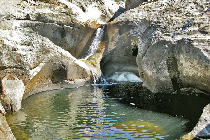
God’s Bath
The 209’s foothills hide a plethora of secret swimming spots, but none as marvelous as God’s Bath. Located in the Clavey River Canyon, this assortment of deep, crystal clear pools and breathtaking waterfalls is just a short hike away. Surrounded by granite formations, there are plenty of pools to explore — including an underwater pathway that adventurous swimmers can follow and pop up on the other side.
Head out of Groveland east on Highway 120 and turn left onto Cherry Lake Road about 15 miles outside of town. Continue on Cherry Lake Road until you reach Cherry Lake, then continue onto Cottonwood Road. After another 15 miles, you will reach the Cottonwood Bridge – park here in one of the pull outs.

Natural Bridges
Swimming in the pools located on the Natural Bridges trail may make you feel like you’re in a scene from a movie. This beautiful, two-mile round-trip hike will lead you to spectacular limestone caverns, carved out over hundreds of years by Coyote Creek. Maintained by the U.S. Bureau of Reclamation, this natural feature is one of their recommended trails when visiting New Melones Lake. The water may be cold, but it’s perfect for a summer cooldown via a swim, wade or raft through the formation. This area is a fragile ecosystem, so dogs and bikes aren’t allowed. During the summer, mid-week visits are best as this secluded spot is a popular destination.
From Highway 4, turn onto Parrots Ferry Road. Go about 4 miles and park at the marked trail head on the right, keeping an eye out for the brown “Natural Bridges Day Use Area” sign on the side of the road.
Cleo’s Bath
Pinecrest Lake is a popular destination for swimmers, but buried back in the lake’s mountains is another hidden gem where hikers can cool off. The picturesque swimming hole known as Cleo’s Bath lies about 1.25 miles as the crow flies from the east end of Pinecrest along the South Fork of the Stanislaus River. The hike there, however, is about four miles long and requires some scrambling over boulders and an uphill climb, but the pool is well worth the effort. Cleo’s Bath consists of two main areas: the main swimming hole, which is a natural pool about 60 feet across and six feet deep, and a smaller swimming hole located directly beneath a waterfall where courageous swimmers can take a leap of faith into the depths.
To reach Cleo’s Bath park at Pinecrest Lake and hike the Pinecrest Lake Loop Trail counterclockwise to the east end. When you reach a small meadow just as the trail begins to climb you will see a sign pointing the way to Cleo’s Bath. Continue on this trail east for another 1.5 miles till you reach the swimming hole.
Swim Safely
According to the U.S. National Park Service, there are a few things you can do to ensure safe swimming in the 209’s natural pools this summer.
● Always supervise children closely, and utilize life jackets when near water.
● Swim only during low water conditions; in summer, rivers and creeks swollen by runoff from snowmelt are dangerous. Stay clear of powerful currents, icy water and river obstructions.
● Make sure any pool you’re jumping into is clear of hidden obstructions before you dive by extensively scouting the area.