Alpine lakes, scenic hikes and exciting summits await. Highway 4 over Ebbetts Pass provides easy access to worthy Sierra Nevada adventures.
If you haven’t discovered the treasures of the Mother Lode’s high country yet, why not venture out this year? Here are three moderate outings near Ebbetts Pass which will deliver more happiness than most Gold Rush miners attained in these parts.
Kinney Lakes
A four-mile loop circles the picturesque Kinney Lakes near Ebbetts Pass. Anglers will enjoy fishing the lakes and anyone will enjoy the clean air and High Sierra view. Children and dogs should like it too.
Take Highway 4 east for about 15 miles from Bear Valley, or Highway 4 west for 18 miles from Markleeville. There’s roadside parking at the pass and in a trailhead lot half a mile east of it.
Hike north on the Pacific Crest Trail past Sherrold Lake, reaching Upper Kinney Lake in about one mile. Here we leave the PCT to take a use trail around Upper Kinney Lake and neighboring Lower Kinney Lake. Many options exist to circle the lakes and return to the road, either out and back or on a loop.
Fun facts: Miwuk and Washoe Indians traveled the Ebbetts Pass corridor, as did Jedediah Smith, the first non-native to cross the Sierra Nevada, surviving a fierce snowstorm in 1827. John “Snowshoe” Thompson delivered mail through this area on his cross country skis from 1856 to 1876.
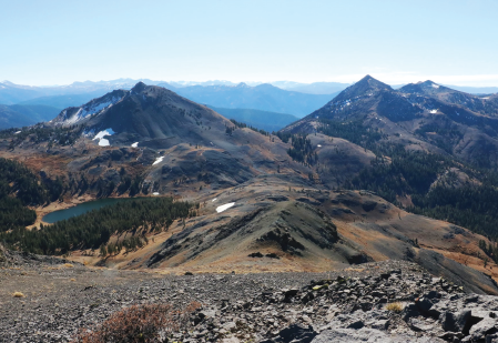
Ebbetts Peak

Starting from Ebbetts Pass, find the dirt road leading northwest. Follow it about a quarter mile to its end. Take the northbound trail up to the saddle and then climb a use trail northeast up the last few hundred feet to the summit.
For variety, descend northwest toward Sherrold Lake where you’ll meet the Pacific Crest Trail. Turn right to take it back to Highway 4, where another right returns you to Ebbetts Pass in a few hundred yards. Making this loop adds only a half mile to the total distance. Be cautious of this option in the early season when the north slope of Ebbetts Peak will have snowfields.
The climb to the 9,160-foot summit and back climbs 424 feet in about a mile, taking most people an hour or less. Take it easy if you just came from low elevation, though.
Fun facts: Pioneer John Ebbetts crossed this pass in 1851. Ebbetts later suggested the route for a transcontinental railroad to surveyor George Goddard. After Ebbetts died in a steamboat explosion in 1854, Goddard named the pass after him. Despite Ebbetts’ vision, no railroad was ever constructed here, though a toll road opened in 1862 to accommodate silver mining. The road became public and free to use in 1911.
Highland Lakes, Folger Peak, Hiram Peak
Get off the main highway and discover the attractive Highland Lakes area. A short and pretty hike leads to the modest Folger Peak summit, suitable for beginners, kids and dogs.
Take Highland Lakes Road leading southeast from Highway 4, about 4 miles east from Hermit Valley Campground if eastbound or 1.3 miles west of Ebbetts Pass if westbound. Drive on the partly-paved, partly dirt road for 5.8 miles to Highland Lakes Campground beside the second and smaller lake. The road can be rough, narrow and windy in places but is generally drivable for cars without high clearance.
Walk through the campground area on the west side of the road and locate site #4. A use trail leads from it through lodgepole pines to the west. Soon you’ll emerge from the trees, turn north and start steeper climbing up a gravely slope. When you reach the secondary peak on the mountain’s southern flank, you’ve gained about 75 percent of the climb’s elevation. The last segment is slightly steeper and rockier than the lower portion but still class 1 if you stay on route. The round-trip outing of 2 miles climbs 1,100 feet to a 9,720-foot summit, taking most people one or two hours.
Or if you’ve had enough hiking, take a refreshing dip or cast your fishing line into the pretty Highland Lakes.
Fun facts: Folger Peak carries the name of an eastern Sierra newspaper pioneer, although no one knows for sure which one. Robert Folger (1820-1899) founded The Alpine Chronicle in 1864 and was the west coast’s oldest working journalist at the time of his death. His brother Alexander Folger (1831-1902, and identified as Andrew by some sources) became the town’s first postmaster and also published newspapers with his brother in Markleeville and Bridgeport. Hiram Peak’s name honors Hiram Tyre, who grazed cattle in the region.